Posts

Gupteshwor Cave - A Tourist Destination in Kusma Municipality Parbat

Image
Gupteshwor Cave - A Tourist Destination in Kusma Municipality Among the various tourist attractions in the Kusma Municipality area, the renowned Gupteshwor Cave stands out. It holds significant importance from historical, religious, cultural, and tourist perspectives, making it a vast and mystical cave with beautifully carved sculptures of various deities, fulfilling the desires of devotees. Believed to be a place where Goddess Parvati meditated after being upset with Lord Shiva and later revealed herself, the cave is named Gupteshwor, signifying the hidden presence of Lord Shiva. During the Lichchhavi era, when the Rajput king Jayapida invaded Nepal, he used the caves in this region for shelter. The local legend suggests that these caves, especially Gupteshwor Cave, played a vital role during that period. In 1991, a group of locals, including Ratnabahadur Karki, Dalbahadur Rana Magar, Shyam Prasad Joshi, Dhan Bahadur Joshi, Sarve Khatri, and Rupanarayan Shrestha, discovered the cave. ...

"Historical tunnel canal "

Image
Location of Tunnel Canal 

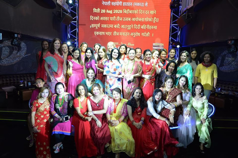
The Origin and Evolution of the Teej Festival

Image
Origin of teej Festival

The Dupcheshwar Mahadev Temple is of religious and touristic significance.

Image
    The origin of the Dupcheshwar Mahadev Temple  When it comes to the origin of this temple, various folklores can be found. According to the mythological story, in ancient times, in the Dupcheshwar Municipality under the Nuwakot district, the cows of Basu Tamang (Vase) who lived in the Gogan Chaur, were lost from his cowshed. Despite searching for the cows in all the surrounding forests, they could not be found. Tired, the cows come back to the cowshed to rest. In the dream at night, a beautiful yogi tells Basu Tamang that your cows are not lost, they are grazing on this hill. The next day when he went to see, the cows were indeed hidden on the same hill, behind the rugged rock of the hill. In the shape of a half-moon, there is a Shiva Lingam on the rock, from which milk is flowing from all four sides. After witnessing this event of cows coming to the rugged hill and milk flowing from the Shiva Lingam, the naming of the Shiva Lingam as Dupcheshwar was done, and an annua...

Kathmandu, Terai, Madhesh, Dharauti road, and Nijgadh international airport have a significant impact on Nijgadh.

Image
  The alternate route plan connecting the federal capital Kathmandu with the Terai region and providing entry to Kathmandu has been constructed as per the standards, and has been inaugurated by the then Prime Minister Pushpa Kamal Dahal on Jestha 14, 2074. Some information about the Kathmandu Terai Expressway Name: Kathmandu Terai Expressway Length: 76 km Date of opening: 2067 BS. Cost of construction: 9.4 billion Estimated construction cost: 11.2 billion Annual fuel savings: 10 billion Annual vehicle maintenance cost: 15 billion Daily vehicle capacity: 5 thousand Date decided by the Nepali government to build it: 2073, Push 7 Formation of the task force: 2073, Push 7 Time to travel from Nijgadh to Kathmandu: 1 hour Shortest route from Kolkata port to Kathmandu Number of small and big bridges: 76 Length of the Surung Expressway: 13 km (from Gagatte to Ratamate) From the Terai to Kathmandu, the Vindu Nijgadh Bazaar three km away, will be the most beneficial area after the constructi...

Religious and tourist sites located in the Nijgadh city area, Nepal

Image
"the viewpoint inside Martyr Hiralal Park" Religious and tourist sites located in the Nijgadh  city area

Gravity Ropeway Information:

Image
  Gravity ropeway system The operation of this ropeway is assisted by the gravitational force of the Earth, making it known as a "Gravity Ropeway." With the help of this system, when goods are lowered from the Upper Station, three times the load can be pulled up from the Lower Station with the same effort. For instance, if 90 kilograms of goods are lowered from the Upper Station, the system can pull up 30 kilograms of goods from the Lower Station. The utilization of gravity eliminates the need for additional fuel. Economic Support This 990-meter-long ropeway is a collaborative initiative between the European Union, Hojefoundation Spain, and Practical Action Nepal along with N.G.O. Network Tanahun. The project received financial support of NPR 11,326,649. Additionally, the Chhimkeshwari Gaun Vikas Samiti contributed NPR 90,000, and local residents provided NPR 2,925,520 through voluntary labor. The construction was completed in the fiscal year 2066 in collaboration with these ...

Important Information about Aviation

Image
The Wright Brothers' Early Flights On October 9, 1910, Clement Ader successfully lifted his aircraft a few centimeters above the ground and flew around 50 meters. However, even before this, a Turkish aircraft had an accident at TIA (Tribhuvan International Airport) on March 4, 2015. This was the first flight of an Avia aircraft, named by Clement. The Latin term "Avia" translates to "bird," signifying flight. The Wright Brothers claimed to have flown before, and among their key claims are the following On March 4, 2015, Turkish airplane.   1.Clément Ader, Eole III (1901-1903) 2.Gustave Whitehead (1901-1903) 3.Richard Pearse, Monoplane (1903-1904) 4.Samuel Pierpont Langley, Aerodrome A (1903) 5.Carl Jatho, Jatho Biplane (1903) 6.Alberto Santos-Dumont, 14-bis (1906) The First Airplane Flight Although there were other claims related to the first flight before the Wright Brothers, the credit for the first successful airplane flight goes to the Wright Brothers (Wilbur...

Second longest suspension bridge of Asia

Image
The western boundary of Nepal is defined by the Mahakali River, and even beyond the Mahakali Gorge, the land belongs to Nepal. In the restructuring of the state, the former Chandani and Dodhara VDCs were amalgamated to form the Gabhar Municipality. In close proximity to the northwestern border of Nepal lies the distinctive Annapurna Himalayan range, renowned as the Annapurna massif, standing out as one of the brightest Himalayan formations. Flowing from this Himalayan range, the river earned its name Mahakali, which also became the namesake for this municipality. In India, this river is known as the Sharda River. The tributaries of this river include Tinkar Khola, Chamelia Khola, and Surniyagad Khola. The average annual flow of this river is 730 cubic meters per second, with a total length of 233 kilometers. In Tanakpur, a dam has been constructed on this river, diverting water into India. This dam is known as the Sharda Barrage in India.

"The Richness of a Vibrant Culture of the Darai."

Background Among the 131 ethnic groups residing in Nepal, Darai is one, despite being a small minority. The impact of rapid urbanization, modernization, and globalization is gradually affecting Darai communities both culturally and economically. Due to the influence of urbanization and modernization, some cultural aspects of this community are diminishing. This study highlights the situation of Darai communities residing in various places in Tanahun district where the effects of urbanization and modernization have led to the loss of certain cultural elements. This study could be significant for all those interested in current and future anthropological studies. Introduction of Darai Why are they called Darai? What is the history and naming process related to their origin? What connections do they have with other ethnic groups? Scholars may have different opinions on such topics, but Darai people themselves can provide comprehensive insights into their own culture. In Ward No. 11 of Vy...